Digitally Planning Your Future
PT. FKA Global is a leading technology services provider of Complete IT Solutions. We are a management-owned enterprise comprising a unique network of companies providing a complete coverage of Indonesia.
PT. FKA Global empowers governments and plant enterprises to connect and collaborate seamlessly in an increasingly connected society where access to information is vital. We understand and commit to the tenet that to be competitive we must be ready and able to design, implement and support complex IT solutions to meet customers’ evolving requirements. By affiliated with worldwide technology leader, AVEVA Group plc, Topcon Positioning Systems. Inc, Siemens, Innovyze. We bring value to the industries among Indonesia for better future.
Our Solution
How we create, capture and deliver value
ASSET MANAGEMENT SOLUTION
Deliver projects on time and improve safety and operational performance with rapid, intuitive access to the Digital Twin.
ENGINEETING SOLUTION
Work effectively together with other engineers to develop and maintain all the key engineering items involved in plant or marine projects.
DIGITAL SURVEY SOLUTION
Our range of solutions in mass data capture opens the door to entirely new workflows. Capture data once, quickly, then interrogate the data at your leisure, on your own at your desk.
PLANT AND MANUFACTURING
Empower your people with a unified platform that spans your entire supply chain
Products & Solutions
AVEVA™ Asset Information Management
AVEVA Asset Information Management a powerful Asset Information Management solution for engineering and operations. It brings together information from multiple sources and in multiple formats to enable users across your business to securely access, visualize, validate and collaborate on the Digital Twin data. READ MORE.
AVEVA™ PI System™
The PI System enables digital transformation through trusted, high-quality operations data. Collect, enhance, and deliver data in real time in any location. Empower engineers and operators. Accelerate the work of analysts and data scientists. Support new business opportunities.. READ MORE.
AVEVA™ E3D Design
Formerly Known As AVEVA Everything 3D
Access 3D designs from any global location with a tablet or mobile device to review and approve model updates, allowing for real-time responses to accelerate project delivery from anywhere in the world. READ MORE.
AVEVA™ P&ID and AVEVA™ Diagrams
Intelligent, graphical, data-driven P&ID design applications that can be used as a stand-alone application or as a fully integrated key part of the AVEVA Unified Engineering suite. READ MORE.
AVEVA™ Electrical and Instrumentation
Create instrumentation and electrical drawings, schematics, data sheets. Integrate with ETAP for detailed calculation and 3D for cable routing. READ MORE.
AVEVA™ Unified Engineering
AVEVA™ Unified Engineering brings together engineering, design and simulation to enable global multi-discipline teams to work concurrently in a common, data-centric environment for maximum transparency and collaboration. READ MORE.
Our Survey Solutions
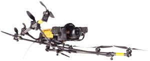
PRECISION, HIGH-RESOLUTION ROTARY-WING UAS WITH TOP-TIER SENSORS.
Powered by Ascending Technologies, the Falcon 8 is a rotary-wing UAS designed for inspection and monitoring or survey and mapping applications.
Features & Benefits:
- Configurable for inspection or surveying
- Use multiple sensors at the same time
- Resistant to magnetic interference
- Operational in windy areas
- Low noise, emission free operation
- Triple redundancy with Topcon Trinity safety systems. READ MORE

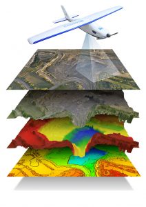
A LIGHTWEIGHT, ROBUST SOLUTION FOR AERIAL MAPPING AND DIGITAL TERRAIN MODELS.
Powered by MAVinci. The Sirius Pro delivers highly accurate aerial mapping results using GNSS-RTK.
Features & Benefits:
- High accuracy aerial mapping using GNSS RTK
- No need to spend time on collecting Ground Control Points
- Auto pilot and assisted flying
- Fully Automatic Landing
- Cruise Speed 65 km/h
- Fully operational up to 50-65 km/h with headwind
- Operates in rain
- High quality camera operated in low light
- Flight plan auto adapts to elevation model
- 30% flight time savings for large UAS areas
- Simple hand launch
- Vertical Facade Capture (Requires City Mapping Kit) READ MORE

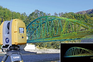
COMPACT AND LIGHTWEIGHT MULTI-ADJUSTABLE LASER SCANNER.
Topcon’s GLS-2000 laser scanners allow you to quickly and accurately capture 3D data at any project site. The compact, lightweight scanners accurately and quickly capture your site in less than 3 minutes with a 360° scan, including images.
Features & Benefits:
- High Accuracy with Precise Scan Technology
- High Speed 360º Dome Scanning
- Long Range
- Dual Camera
- Eye Safe, Selectable Laser Technology
- Compact, Lightweight, Rugged Design READ MORE

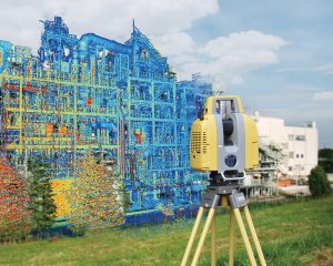
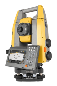
FAST, ACCURATE LAYOUT AND SURVEY IN ANY CONDITIONS
The flagship GT Series ultrasonic robotic total station delivers accurate and productive workflows for highly demanding survey and construction applications. Lay out or survey more points precisely and in less time, while improving quality and consistency. Easy-to-use digital processes with repeatable accurate results mean less rework and better-quality control. Built for jobsite mobility, GT is one professional tool that does it all for layout, survey and machine guidance.
Features & Benefits:
- Precise positioning with single-person operation
- High-speed advanced ultrasonic motors
- Easy to use with MAGNET or Pocket3D software
- Seamless integration into BIM workflows
- Available in GT-1200 and GT-600 models with multiple accuracy levels
- Three-year instrument and five-year motor warranty
- Ultra-rugged IP65 dust and water resistance. READ MORE

Address
Head Office :
Kindo Square
Jl. Duren Tiga Raya No. 101 Blok B2
Jakarta Selatan 12760
INDONESIA
Phone : +62 21 79198904
Fax : +62 21 22792939
Email : admin@fkaglobal.com
